Practical GIS training your team can apply straight away
Hands-on training designed around real workflows, real use cases, and real operational value — not generic software demos that don’t connect to your team’s actual work.

Practical GIS training your team can apply straight away
Hands-on training designed around real workflows, real use cases, and real operational value — not generic software demos that don’t connect to your team’s actual work.

Most GIS courses teach software. They show people how to use features — but not how to apply those features in the context of their actual job. Participants return to the office, open QGIS, and are not sure where to start.
The result is that training investment is wasted, GIS capability doesn’t spread, and the specialist team remains the bottleneck for everything spatial.
Training built around your environment — your data, your systems, your use cases — changes that. People leave knowing exactly what to do on Monday morning.
We start by understanding who needs training, what they need to do with GIS, and what they already know. This shapes the content, pace, and format of the session.
We design training around your actual systems and data — so exercises and examples are directly relevant to participants' day-to-day work, not generic scenarios.
We run hands-on sessions where participants work through real tasks using your tools and your data. We focus on practical application, not feature walkthroughs.
We provide reference guides and follow-up support so skills are reinforced after the session. We can also run refresher sessions as the team's needs evolve.
What does training for GIS professionals cover?
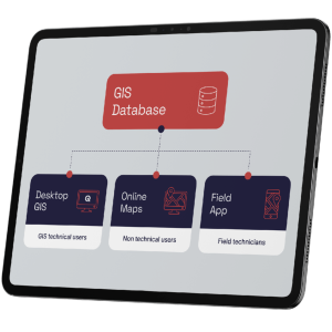
Mergin Maps for field data collection, web maps deployment, QGIS, spatial database management, configuration, data quality, and enterprise GIS administration.
What do power users learn?
Creating web maps and desktop GIS for day-to-day tasks: managing users, layer management, spatial queries, map printing and data editing.
What training do field teams receive?
Mobile data collection using Mergin Maps: form setup, GPS capture, photo recording, offline use, and data synchronisation.
What do managers and executives gain from training?
Reading and interpreting GIS outputs, understanding spatial data governance, and using dashboards to track operational performance — without needing specialist GIS skills.